Category: hiking

  • The Donner Tunnels: Hiking, Railroad History & Street Art

    Map of the Donner Tunnel Hike

    The problem with being alone after about 50 years of living with your best friend, is that it’s easy to get bored especially when you have few friends and relatives where you live. Today was one of those days. It’s too frigging hot (100+ F) for outdoor activities, and I did not feel like working out and hanging out at the club. Or walking aimlessly around a shopping mall (have me committed if I ever start doing that). This would be a good day to either be underground or someplace else cooler than anywhere in the Sacramento Valley. What to do. I had been planning to do the Donner Tunnel hike sometime this summer – higher altitude, nice cool tunnels, interesting engineering and history, and less than a two hour drive up I-80. A good choice for a boring, incredibly hot day.

    A bit of history – the Donner Tunnels (15 of them I think) were built in the late 1860’s by 1000’s of Chinese laborers, as part of the Transcontinental Railroad. They had to drill and blast through solid granite, build massive retaining walls, and probably lay the track as well. Aside from the rock tunnels, the railroad also constructed lengthy snow sheds to protect the tracks from deep snowfall and avalanches. Some of these are at least a mile long, and connect to the tunnels – these were originally wood, and were eventually replaced in the 1900’s by massive concrete structures. Pretty amazing engineering and construction techniques.

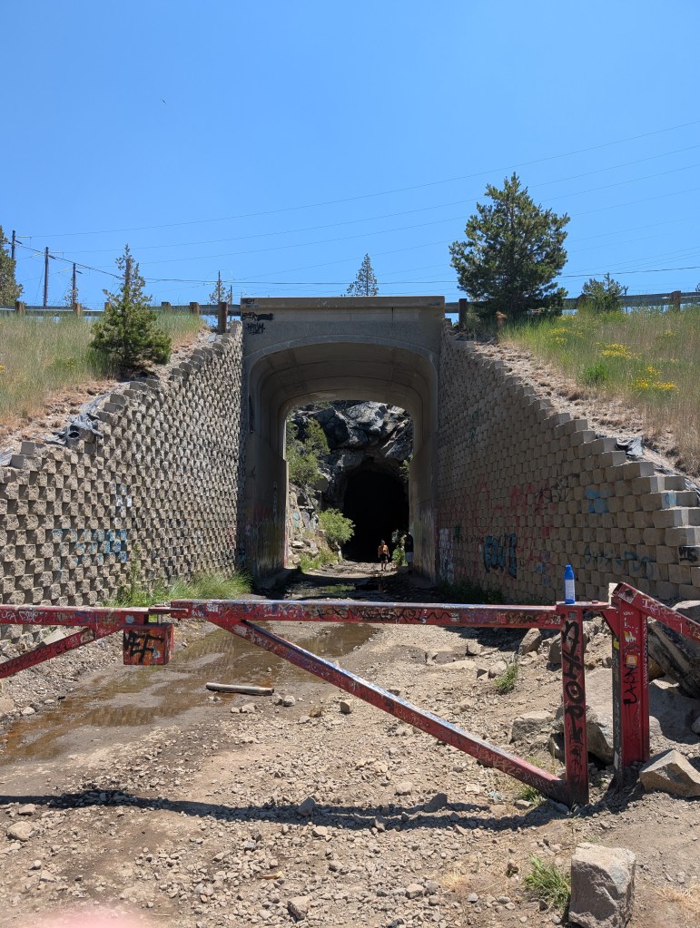
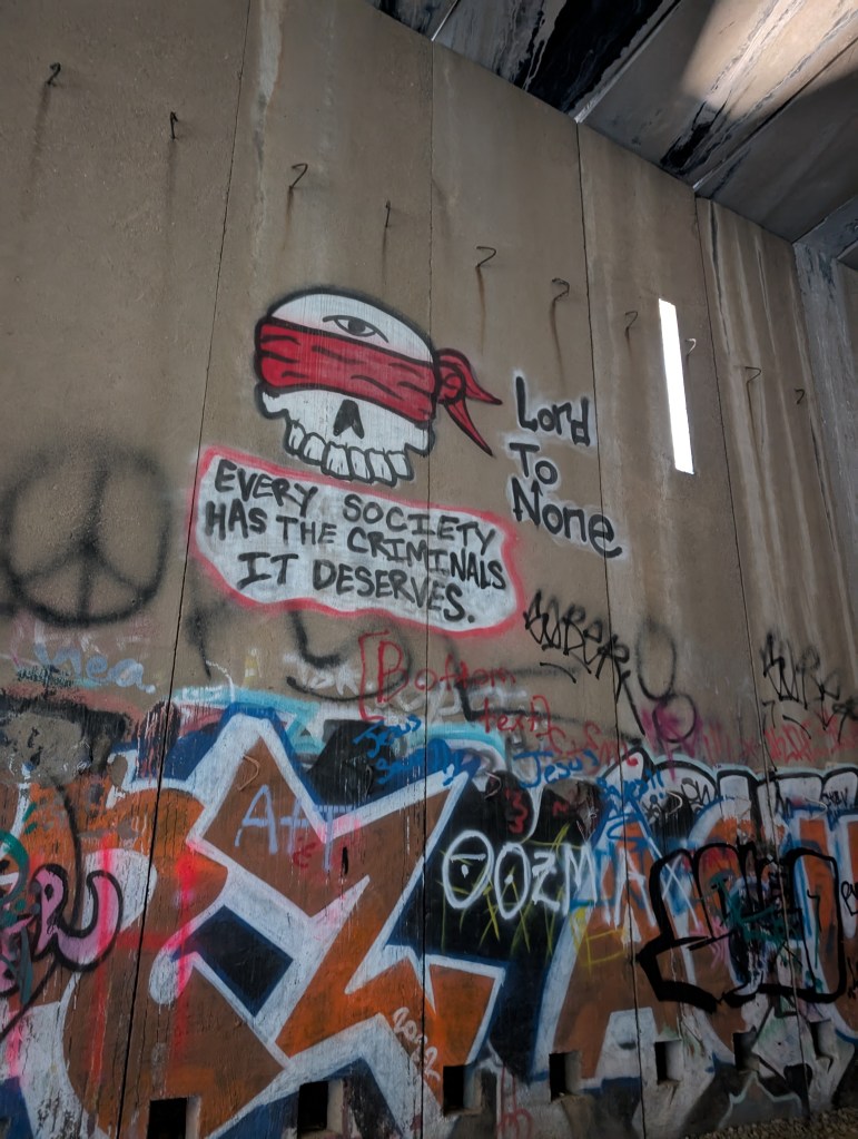
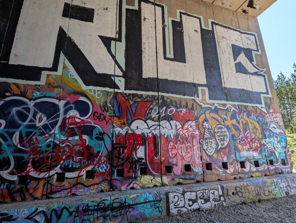
    Once the rail line was abandoned (1993), the rails were torn out, leaving a very nice place to hike – it has lots of shade for hot days, nice views of the surrounding mountains when you are not in a tunnel/shed, and a nice gravel path that stretches for miles. You do not need a map – no chance of getting lost unless you really want to. The seemingly endless and enormous concrete shed walls became a magnet for graffiti artists, so the walls now have layers of colorful and imaginative murals, as well as the usual scrawls you see in cities. It’s a fun hike – not too strenuous, good place to bring the kids and dogs. And a great place for all kinds of photography. My kind of place.

    I had a nice easy drive up I-80, and the instructions were pretty accurate for where to park – there were quite a few cars already there, and the way to the tunnels was obvious. I loaded up my pack, stuck my GoPro clip on my shoulder strap, grabbed my headlamp, and headed off to parts unknown.

    View from the parking lot to Tunnel #6

    The first tunnel you enter is actually the longest one – Tunnel #6. It is also the darkest since it goes through solid granite. There is a shallow stream running through it to add a little challenge to the journey. This was the only place where you really need a flashlight or head lamp (preferred). The path in this tunnel has a lot of rocks, not just gravel, and it would be a painful and wet fall if you trip on one. There is not much to see on the walls (it’s really dark), so the safest choice would be to look in front of you most of the way. It’s weird that as you get closer to the end of the tunnel, it’s more difficult to pick out what’s in front of you – the light is blinding. It was a bit creepy, but not too difficult.

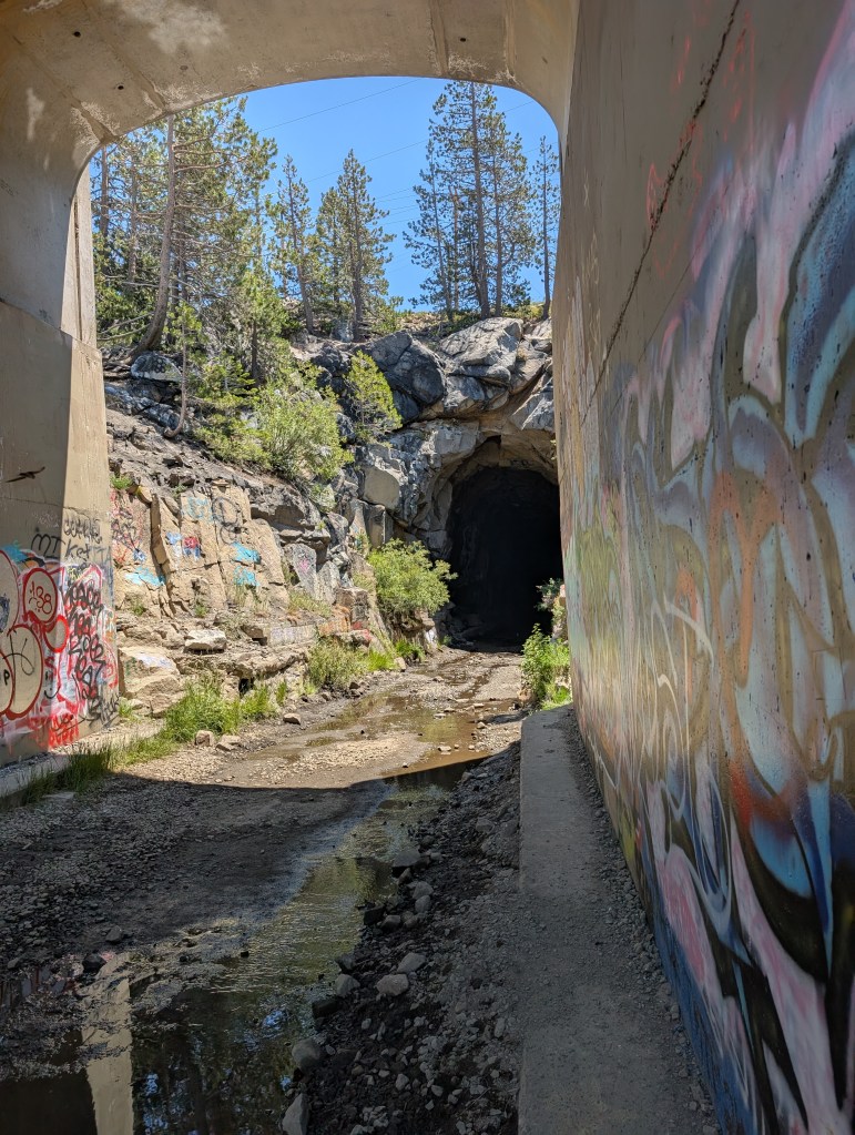
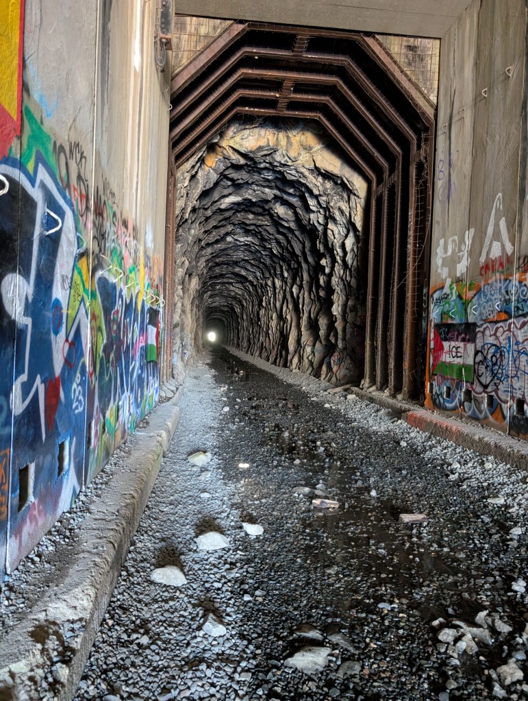
    After Tunnel #6, it seems like the rest of the rock tunnels are short and dry, and have a snow sheds attached. This is where the graffiti really starts, more so at the end of the tunnels/sheds, but quite a bit through the lengths of the sheds as well. The concrete structures have openings for light and air through the length of each shed, so you do not need flashlights unless you are walking though the attached rock tunnel, and those are short. The openings provided enough light for the graffiti artists, so there is a lot of interesting works along the way.

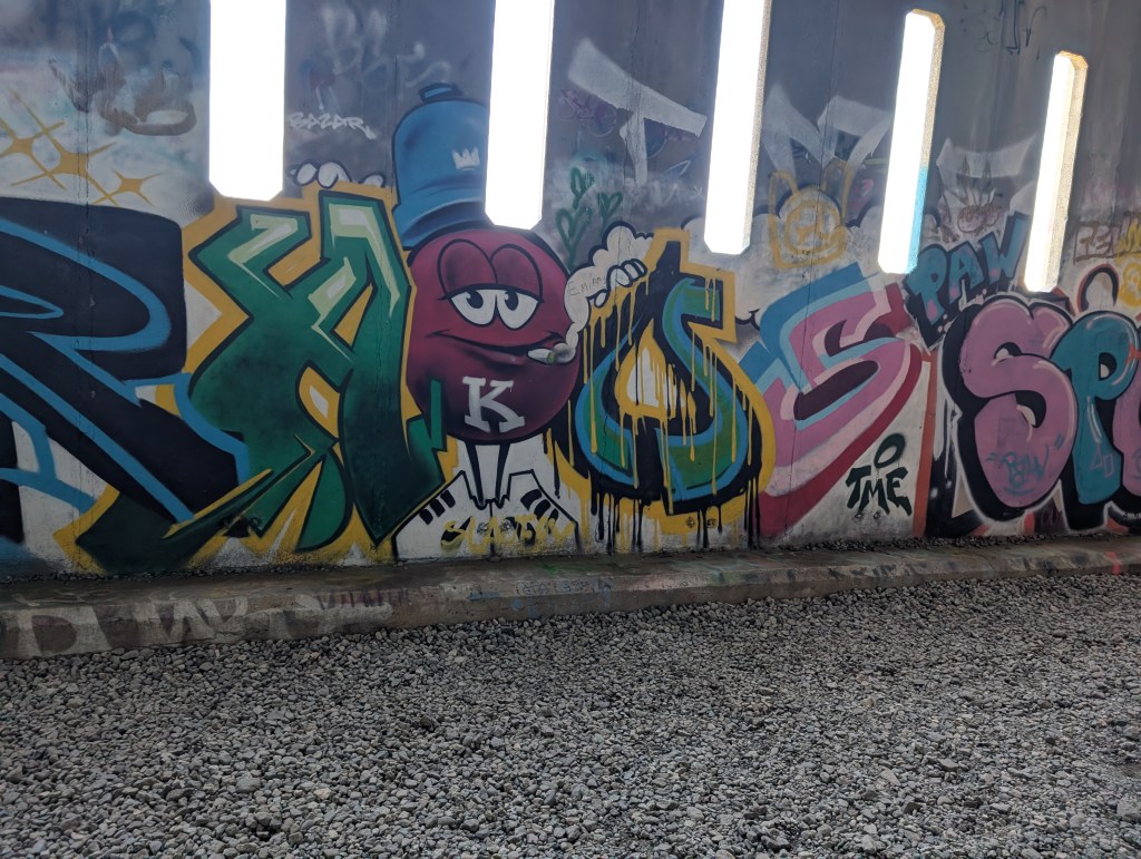
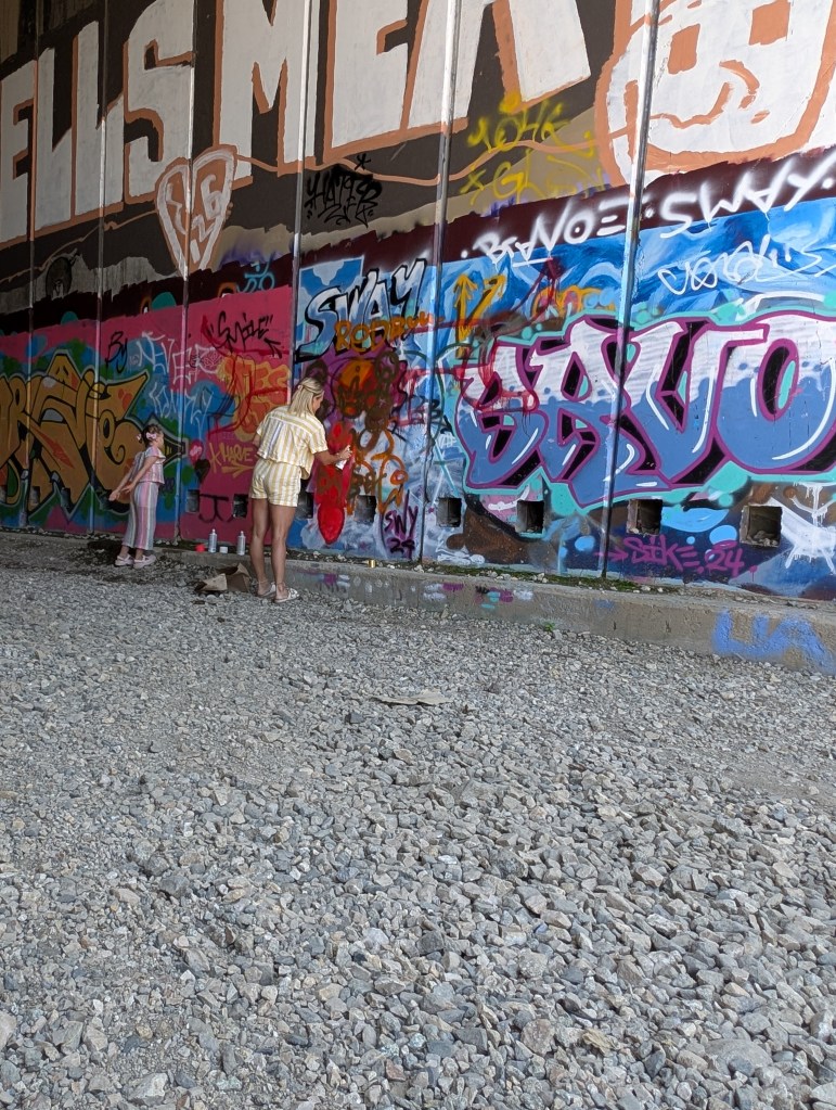
    This hike is extremely popular – I imagine it is very crowded on the weekends. Lots of families and groups. There were also a few graffiti contributors while I was there. Some families bring a bag of spray paint cans, and let the kids have at it. And then there was one woman with 3 kids, who was also spraying away while I was taking a water break. I of course critiqued her art work, which was just a blob of red paint. She finally gave up on whatever she was trying to create, covered it over in white paint as a canvas, and intended to start over. I applauded her effort. I’ll photograph it the next time I’m there. She’ll be famous then. It’s a shame that there are not enough open walls for the novices to play on – they wind up covering over some really interesting murals, that talented artists created. Somebody should have created a book of the best murals. Too late now.

    Here is a bunch of photo’s of the graffiti and the long snow shed.

    And a couple of more from the outside

    I decided to call it quits at the entrance to the fourth shed (where the struggling graffiti artist was plying her trade) – I was not tired, I just wanted to get back home at a reasonable hour. I also wanted to try a different way of anchoring the GoPro for the return trip. On the way out, I had the GoPro on a clip attached to my shoulder strap – no matter how much I tried to adjust it, the camera was alway pointing to on side. Heading back, I put my Sony in the backpack to get it out of the way, and just held the GoPro in front of me (while holding my hiking stick in the other hand. The results were much better. The video below starts in a shed, and transitions into the very dark Tunnel #6. I have a few other videos I’ll attach later on, once I do some editing. The first is the walk back through dark Tunnel #6

    The next video shows all the street art in part of the long snow shed, and also how you can go from sunny to very dark…a bit creepy.

    This was a fun trip, quite different from some of the other strange adventures I’ve had this summer. I’m going to try and get a small group together to do the full hike, which is only about 5 miles or so round trip. This time, I’ll remember to change batteries in the headlamp. And bring some spares. You can never be too cautious. 

    If you do plan to try this hike out, here are a few important tips:

    1 – Wear comfortable walking shoes – the trail is gravel the entire way. I guess if you are used to hiking in flip-flops, you’ll be OK. It’s also wet in Tunnel #6.
    2 – Bring a flashlight or headlamp – it’s really dark in that first tunnel, and dim in a few other spots.
    3 – If you really have to add your own art or scrawls, try not to do it on any of the large murals.
    4 – And most important of all – there are no restrooms in the parking lot, or along the 2.9 mile length of the trial. It would also be inappropriate to do it in a tunnel or snow shed. If you need to go, go before you get there.

  • No Wave but a nice White Pocket

    Edge of the White Pocket

    This post is Part II of the previous post, which covered my Road Scholars trip to the two National Parks in Utah. As I briefly mentioned before, I decided to try for a hike called “The Wave” – very well known among hikers in the South West, both for the amazing sandstone formation with waves of flowing, layered sandstone, as well as the notoriously difficult trail to get there – difficult in that the trail is not marked, and you can wind up lost in the desert. Here’s what the Wave looks like (not my photograph)

    Not my photo – grabbed it off of the Web. No author indicated

    The Wave is a regulated hike in the North Coyote Buttes, within the Vermillion Cliffs National Monument. It is only a 3.5 mile hike to get to it, but the trail is not marked, and it’s easy to get off-trail, something you don’t want to do in a desert. Access is managed by the BLM, and you have to get a permit either through the monthly lottery on the recreation.gov website, or a daily permit, again through a lottery on the same site. For the daily permits, you can only submit an application if you are physically within a geo-fenced area between Kanab and Page AZ. Only 64 permits are granted each day. I had no luck on the monthly lottery for the past 5 months, so since I would wind up a 90 minute drive from St. George to Kanab, I thought it would be worth a try after I was done with the Road Scholars trip. Not wanting to chance getting lost on my own, I signed up with a local touring company (Kanab Touring Company) for a private guide. Since there was no guarantee of getting the permit, I was also signed up for an alternative tour to a non-permitted area in the same National Monument – The White Pocket. I had everyone on the Road Scholars tour crossing their fingers for me. 

    So, that was the long story of what I was hoping for on my solo trip extension. And here is the rest of the story, of what actually happened.

    I headed out from St. George in the morning after our farewell dinner. It’s a relatively short drive from St. George, going back through part of the route to Zion. It was a beautiful drive – like being in one of the old Western movies (many of which were filmed in this area). There was no traffic, and I made the trip in nothing flat. My first goal was to do some laundry – after 10 days of travel and hiking, the laundry bag was getting full (and a little fragrant). Kanab has a really nice combo laundromat and car wash. I passed on the car wash. 

    More than enough to get me home in a week

    The laundromat had Wifi, so I was able to submit my permit application for the Wave, targeted for Tuesday (it was Sunday). I would find out that evening if I was successful, in which case, I would pick up the permit on Monday. After finishing laundry, I decided to ignore my initial plan of taking a day off from hiking to give my aching knees a rest. Heck, there were so many trails in the area and absolutely incredible rock formations, that I had to do something. So, I decided to do a hike on a trail named “Dinosaur Footprints Trail”. It was marked as easy. What could go wrong? I set out without water or a pack since it was only less than a mile to get there. But, there were a lot of vertical portions, on loose rock, small ravines, and the trail was hard to find as you went up. A bunch of people passed me on the way down, and there were very few cars in the parking lot. I thought about turning around but of course, kept on trucking. The trail got worse since I was not on a trail, and I was starting to get concerned about being by myself. Then I heard voices. Real people, not in my head. A nice couple was above me, searching for the dinosaur footprints. Once I scrambled up there, they asked why I was coming up the cliff, when there was an easier trail. Duh. They asked if I wanted to follow them down once we found the footprints. I gladly accepted the offer. The footprints were almost impossible to find unless you knew what you were looking for (I did, so did the other guy….another geologist). And when we found some, they were really weathered out. The trail down was much easier than what I was on, so I made it down safely.

    Trail looks easy enough – it was if you stayed on it
    A very eroded footprint (therapod). The others we found were about the same.

    I think I now have a guardian angel keeping an eye out for when I’m doing something stupid. The angel’s name is Jan. I need that. I tend to do a lot of stupid things.

    I avoided doing any more hikes after that, checked into the hotel (a really nice Hamden Inn), soaked in the spa for a while, and had a nice dinner. The town is really setup for walking – a lot of nice restaurants all along the main drag, which is also where most of the hotels are located. THere is also a really nice grocery store. And what’s really cool, are all the metal stands all along the street, with photos and stories about all the movie stars who have stayed in Kanab while filming Western movies and TV shows. It was fun just walking down the streets, and finding ones I remembered from the old western shows I watched growing up. Jeez, that’s a long time ago.

    That evening, while I was having an excellent dinner (and a G&T), I got the bad news. I did not get a permit. The touring company also submitted a request, and they were also unsuccessful. So, I would be doing the White Pocket on Wednesday. Darn. I’m on a bad streak with permit lotteries since getting a Half Dome permit on the first try. 

    I now had Day 2 in Kanab wide open for whatever I felt like doing. How about a nice (safe) hike? Sure. I had already picked one out, someplace that would probably have a bunch of other people. It had an interesting name – Toadstool Hoodoos, in the Escalante National Monument. How could I resist? This time I geared up with food and plenty of of water (2 liter bladder in my pack). The trail head was about 40 minutes from Kanab, and pretty easy to find – big parking area with porta-potties. A good sign. It was a nice day – not too hot, and relatively light winds…which were supposed to pick up later in the day. The trail to the hoodoos was nice and easy following a sandy wash. It was really obvious when you reached the hoodoos.

    Indiana Jones at the Hoodoos. Notice the pack, with food, 2 liters of water, emergency gear. Not taking any chances

    This was not a toadstool. Once you step past, there was a very large, flat area with these odd, small lumps of sandstone with a capstone on top. Some were only four feet high. Very strange. Very hard to figure out how/why they were there, unlike the hoodoos in Bryce Canyon. 

    Very strange – far from the cliff, and scattered around on a flat area.
    Have to wonder how long that big one will last

    I spent a few hours wandering around – it was fun taking time to setup shots, and just enjoy the strange landscape. Then all of a sudden, the wind picked. Not a breeze – steady, strong gusts that were blowing the fine grained sand at enough velocity to sting bare flesh. Ouch. Seemed like a good time to beat a hasty retreat back to my traveling closet (Subaru). Which I did. The wind was blowing so strong by then, that people were turning back at the parking lot. Glad I got there early.

    I was now left with a decision on what to do with the rest of the day. Looking at the map, noticed I was less than an hours drive from Page AZ, and the horse shoe bend of the Colorado River. Woo hoo! I last saw that 53 years ago on my first geology field camp in undergraduate school. Things have changed….not the river – that would take tens (or hundreds) of thousands of years to alter the course of the river. What had changed was Page, which is now a giant commercial strip mall (nicely done though), and it now costs $15 to park your car so you can walk the .75 miles to the overlook, on a broad path with shaded resting spots. The place was packed with tourists, and when you get down to the viewing area, you have a large number of idiots who take selfies along the cliff edge. It’s a long way down if you slip. And you would hit rock before water. They have railings along the edge for a good reason. I laughed when I heard some guy’s wife yelling at him to move away from the edge. At least he listened. 

    Colorado River Horseshoe Bend

    Notice the boat wakes in the river – that was something new I guess, coming downstream from Lake Mead. 


    That was the end of my day off – I headed back to Kanab since I had an early start for the White Pocket. I stopped at the Kanab Touring Company office on the way back – great shop. Aside from their office, there was a nice coffee shop, and some all kinds of clothing and hiking gear. I got the name of my guide (Dan), who would pick me up at the hotel at 7. I found another good restaurant (great beer), and wandered around town for a bit, before heading back to the hotel.

    And now for the grand finale of the trip (not quite…a few more posts after this). Dan, showed up on time in a huge, off-road equipped Jeep (huge tires, winch) and off we drove to Arizona (Kanab is right on the border, and it was nice to have the time change too). I had thought about driving on my own with the Subaru – I’m glad I did not. The road to this place has deep sand pockets which can swallow SUV’s, even if they are 4-wheel drive. Lots of sharp rocks too. 

    The guide was a great driver, and an interesting character, and we hit it off well. We eventually pulled into the parking area, which is about maybe a 100 yard stroll in the sand to the start of the sandstone formations. The White Pocket is sort of like this weird island in the middle of the sandy desert. And I do mean weird. It’s hard to describe it – from a geologic perspective, it is one single sandstone formation (Navaho), but it is totally chaotic. It is like someone just squished the layered sandstone, and then twisted it around a few times. There are streaks of colored rock, weird twisted formations, and large areas of white sandstone which have hexagonal shapes covering the surface – it looks like a giant quilt some giant layed out on the ground.

    The pocket, from the parking area – notice the big, white quilt.

    There are no trails at all. You just wander around the “island”, carefully walking along the uneven surface, climbing/scrambling in some places, and gaze in wonder at this strange place. It was nice having a guide to help in a few places since I have balance issues, and he just let me lead along whenever I wanted to stop and photograph for a while. 

    And once you walk on, its a wonderland of shapes
    Quilted surface – hard to walk on. Some of the pools had shrimp and tadpoles
    I loved the converging streaks. Not as good as the Wave, but nice
    Strange shapes everywhere. No trails, you just wander
    That’s my guide. Good for perspective of how big this is
    Not too many trees there

    We spent over two and half hours, just taking our time to cover the entire formation. Probably walked 2 or 3 miles. The weather was great, nice and cool, but extremely windy. After a while, it was becoming dangerous for me (those balance issues again), so we wandered back to the Jeep to begin the ride back. That too was fun – he followed a rough 4-wheel drive trail back to the main road which goes along the North and South Coyote Buttes areas, so I got to see the starting point for the Wave. We also passed by some “interesting” rock formations (picture below). Kind of look like the turd emoji, but are called teepees. 

    A pile of teepees
    Teepee or emojee?

    This was a very expensive adventure – all the touring companies charge a lot for a private tour, but it was worth it to be able to focus on what I wanted to do – photography. I’ll keep trying for the Wave, and will go with the same touring company if I get the permit some day. I’d go back to Kanab anyway to hike/photograph some of the other areas that are close by – Zion, the north rim of the Grand Canyon, Escalante…..all a short drive away. More places to add to my ever growing punch list. 

    So ended my hiking adventure. I returned to the hotel, started loading up the car, and had another nice dinner (I really like Kanab). The next day, I would start my very long trip back home. But, the adventure was not quite over.