
This post is Part II of the previous post, which covered my Road Scholars trip to the two National Parks in Utah. As I briefly mentioned before, I decided to try for a hike called “The Wave” – very well known among hikers in the South West, both for the amazing sandstone formation with waves of flowing, layered sandstone, as well as the notoriously difficult trail to get there – difficult in that the trail is not marked, and you can wind up lost in the desert. Here’s what the Wave looks like (not my photograph)

The Wave is a regulated hike in the North Coyote Buttes, within the Vermillion Cliffs National Monument. It is only a 3.5 mile hike to get to it, but the trail is not marked, and it’s easy to get off-trail, something you don’t want to do in a desert. Access is managed by the BLM, and you have to get a permit either through the monthly lottery on the recreation.gov website, or a daily permit, again through a lottery on the same site. For the daily permits, you can only submit an application if you are physically within a geo-fenced area between Kanab and Page AZ. Only 64 permits are granted each day. I had no luck on the monthly lottery for the past 5 months, so since I would wind up a 90 minute drive from St. George to Kanab, I thought it would be worth a try after I was done with the Road Scholars trip. Not wanting to chance getting lost on my own, I signed up with a local touring company (Kanab Touring Company) for a private guide. Since there was no guarantee of getting the permit, I was also signed up for an alternative tour to a non-permitted area in the same National Monument – The White Pocket. I had everyone on the Road Scholars tour crossing their fingers for me.
So, that was the long story of what I was hoping for on my solo trip extension. And here is the rest of the story, of what actually happened.
I headed out from St. George in the morning after our farewell dinner. It’s a relatively short drive from St. George, going back through part of the route to Zion. It was a beautiful drive – like being in one of the old Western movies (many of which were filmed in this area). There was no traffic, and I made the trip in nothing flat. My first goal was to do some laundry – after 10 days of travel and hiking, the laundry bag was getting full (and a little fragrant). Kanab has a really nice combo laundromat and car wash. I passed on the car wash.

The laundromat had Wifi, so I was able to submit my permit application for the Wave, targeted for Tuesday (it was Sunday). I would find out that evening if I was successful, in which case, I would pick up the permit on Monday. After finishing laundry, I decided to ignore my initial plan of taking a day off from hiking to give my aching knees a rest. Heck, there were so many trails in the area and absolutely incredible rock formations, that I had to do something. So, I decided to do a hike on a trail named “Dinosaur Footprints Trail”. It was marked as easy. What could go wrong? I set out without water or a pack since it was only less than a mile to get there. But, there were a lot of vertical portions, on loose rock, small ravines, and the trail was hard to find as you went up. A bunch of people passed me on the way down, and there were very few cars in the parking lot. I thought about turning around but of course, kept on trucking. The trail got worse since I was not on a trail, and I was starting to get concerned about being by myself. Then I heard voices. Real people, not in my head. A nice couple was above me, searching for the dinosaur footprints. Once I scrambled up there, they asked why I was coming up the cliff, when there was an easier trail. Duh. They asked if I wanted to follow them down once we found the footprints. I gladly accepted the offer. The footprints were almost impossible to find unless you knew what you were looking for (I did, so did the other guy….another geologist). And when we found some, they were really weathered out. The trail down was much easier than what I was on, so I made it down safely.


I think I now have a guardian angel keeping an eye out for when I’m doing something stupid. The angel’s name is Jan. I need that. I tend to do a lot of stupid things.
I avoided doing any more hikes after that, checked into the hotel (a really nice Hamden Inn), soaked in the spa for a while, and had a nice dinner. The town is really setup for walking – a lot of nice restaurants all along the main drag, which is also where most of the hotels are located. THere is also a really nice grocery store. And what’s really cool, are all the metal stands all along the street, with photos and stories about all the movie stars who have stayed in Kanab while filming Western movies and TV shows. It was fun just walking down the streets, and finding ones I remembered from the old western shows I watched growing up. Jeez, that’s a long time ago.
That evening, while I was having an excellent dinner (and a G&T), I got the bad news. I did not get a permit. The touring company also submitted a request, and they were also unsuccessful. So, I would be doing the White Pocket on Wednesday. Darn. I’m on a bad streak with permit lotteries since getting a Half Dome permit on the first try.
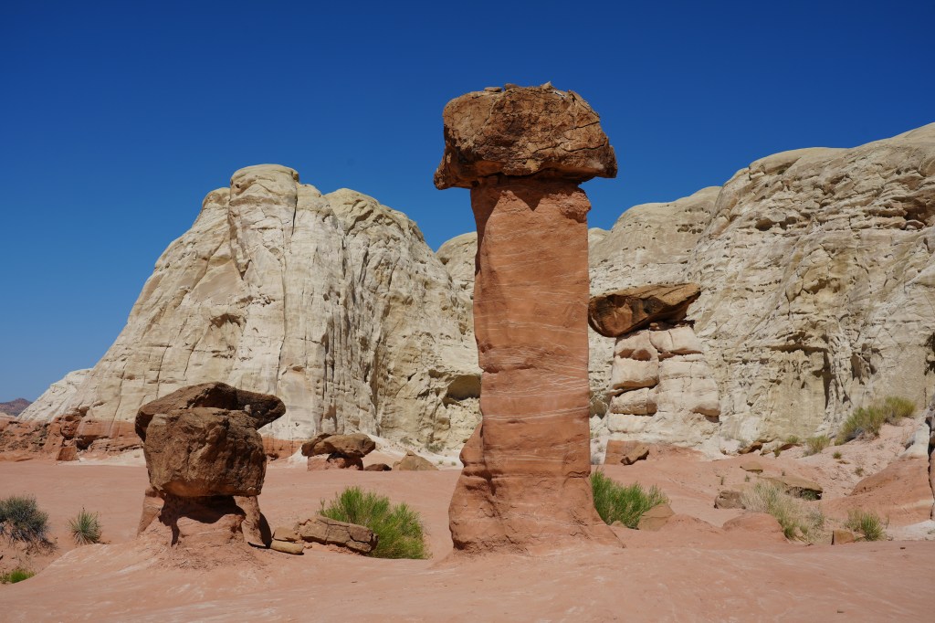
I now had Day 2 in Kanab wide open for whatever I felt like doing. How about a nice (safe) hike? Sure. I had already picked one out, someplace that would probably have a bunch of other people. It had an interesting name – Toadstool Hoodoos, in the Escalante National Monument. How could I resist? This time I geared up with food and plenty of of water (2 liter bladder in my pack). The trail head was about 40 minutes from Kanab, and pretty easy to find – big parking area with porta-potties. A good sign. It was a nice day – not too hot, and relatively light winds…which were supposed to pick up later in the day. The trail to the hoodoos was nice and easy following a sandy wash. It was really obvious when you reached the hoodoos.

This was not a toadstool. Once you step past, there was a very large, flat area with these odd, small lumps of sandstone with a capstone on top. Some were only four feet high. Very strange. Very hard to figure out how/why they were there, unlike the hoodoos in Bryce Canyon.


I spent a few hours wandering around – it was fun taking time to setup shots, and just enjoy the strange landscape. Then all of a sudden, the wind picked. Not a breeze – steady, strong gusts that were blowing the fine grained sand at enough velocity to sting bare flesh. Ouch. Seemed like a good time to beat a hasty retreat back to my traveling closet (Subaru). Which I did. The wind was blowing so strong by then, that people were turning back at the parking lot. Glad I got there early.
I was now left with a decision on what to do with the rest of the day. Looking at the map, noticed I was less than an hours drive from Page AZ, and the horse shoe bend of the Colorado River. Woo hoo! I last saw that 53 years ago on my first geology field camp in undergraduate school. Things have changed….not the river – that would take tens (or hundreds) of thousands of years to alter the course of the river. What had changed was Page, which is now a giant commercial strip mall (nicely done though), and it now costs $15 to park your car so you can walk the .75 miles to the overlook, on a broad path with shaded resting spots. The place was packed with tourists, and when you get down to the viewing area, you have a large number of idiots who take selfies along the cliff edge. It’s a long way down if you slip. And you would hit rock before water. They have railings along the edge for a good reason. I laughed when I heard some guy’s wife yelling at him to move away from the edge. At least he listened.

Notice the boat wakes in the river – that was something new I guess, coming downstream from Lake Mead.
That was the end of my day off – I headed back to Kanab since I had an early start for the White Pocket. I stopped at the Kanab Touring Company office on the way back – great shop. Aside from their office, there was a nice coffee shop, and some all kinds of clothing and hiking gear. I got the name of my guide (Dan), who would pick me up at the hotel at 7. I found another good restaurant (great beer), and wandered around town for a bit, before heading back to the hotel.
And now for the grand finale of the trip (not quite…a few more posts after this). Dan, showed up on time in a huge, off-road equipped Jeep (huge tires, winch) and off we drove to Arizona (Kanab is right on the border, and it was nice to have the time change too). I had thought about driving on my own with the Subaru – I’m glad I did not. The road to this place has deep sand pockets which can swallow SUV’s, even if they are 4-wheel drive. Lots of sharp rocks too.
The guide was a great driver, and an interesting character, and we hit it off well. We eventually pulled into the parking area, which is about maybe a 100 yard stroll in the sand to the start of the sandstone formations. The White Pocket is sort of like this weird island in the middle of the sandy desert. And I do mean weird. It’s hard to describe it – from a geologic perspective, it is one single sandstone formation (Navaho), but it is totally chaotic. It is like someone just squished the layered sandstone, and then twisted it around a few times. There are streaks of colored rock, weird twisted formations, and large areas of white sandstone which have hexagonal shapes covering the surface – it looks like a giant quilt some giant layed out on the ground.

There are no trails at all. You just wander around the “island”, carefully walking along the uneven surface, climbing/scrambling in some places, and gaze in wonder at this strange place. It was nice having a guide to help in a few places since I have balance issues, and he just let me lead along whenever I wanted to stop and photograph for a while.


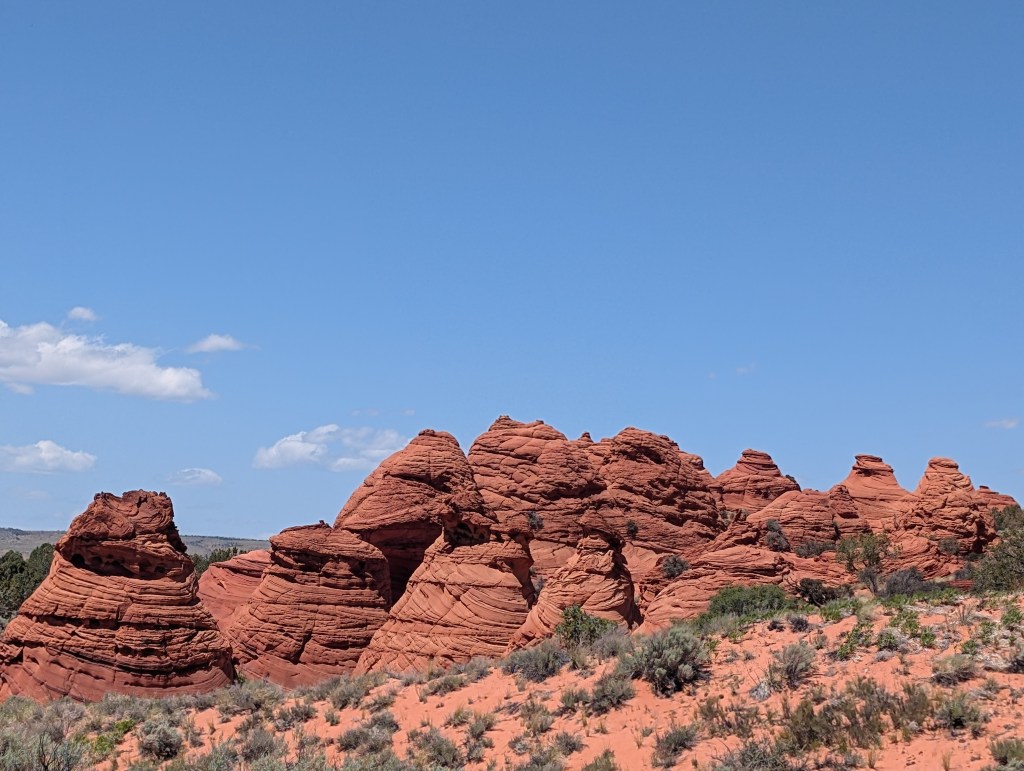
We spent over two and half hours, just taking our time to cover the entire formation. Probably walked 2 or 3 miles. The weather was great, nice and cool, but extremely windy. After a while, it was becoming dangerous for me (those balance issues again), so we wandered back to the Jeep to begin the ride back. That too was fun – he followed a rough 4-wheel drive trail back to the main road which goes along the North and South Coyote Buttes areas, so I got to see the starting point for the Wave. We also passed by some “interesting” rock formations (picture below). Kind of look like the turd emoji, but are called teepees.

This was a very expensive adventure – all the touring companies charge a lot for a private tour, but it was worth it to be able to focus on what I wanted to do – photography. I’ll keep trying for the Wave, and will go with the same touring company if I get the permit some day. I’d go back to Kanab anyway to hike/photograph some of the other areas that are close by – Zion, the north rim of the Grand Canyon, Escalante…..all a short drive away. More places to add to my ever growing punch list.
So ended my hiking adventure. I returned to the hotel, started loading up the car, and had another nice dinner (I really like Kanab). The next day, I would start my very long trip back home. But, the adventure was not quite over.
